Geographic Information Systems - An Enabling Technology
  Why GIS? Why GIS?
Why GIS Belongs in the Data Warehouse
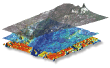
The image at the right is the Northridge earthquake fault line. The image is a composition of satellite data from Earthsat (AVR) and vector data from multiple sources. (layers top to bottom: composition, vector, AVR. Nautilus Systems did the analysis to provide a visualization of the Northridge plate for FEMA.
Why GIS?
 A direct, bottom line connection exists between a business and its geography and the geography of its customers and competition. A direct, bottom line connection exists between a business and its geography and the geography of its customers and competition.
Businesses rely on customers, inventory, and transportation. All involve geographic locations.
Maps are not only useful in strategic location of business operations, but also are powerful tools for analyzing trends and patterns.
Nautilus Systems can help you put your data on a map. Geographic location can be a key to tying together data from different sources. We can work with your data to set you up so that using GIS tools, you can display, compare and analyze data along multiple dimensions, such as the locations of your customers versus your sales locations, and travel distances.
Our specialty is 'spatially enabling' our data mining analyses so that businesses can see the results geographically. This is also called business geographics.
Why GIS Belongs in the Data Warehouse
A data warehouse is a collection of operational data from many sources that has been summarized, reconciled and made available to the corporate decision-maker. Whether the task is targeted marketing, customer demand forecasting, revenue forecasting or competitive analysis in a given demographic region--all of this and more can be accomplished with increased efficiency using GIS.
 Construction of the data warehouse requires reorganizing operational data, extracting relevant historical data, and providing analysis tools. Specialized data warehouses are called data marts. A marketing data mart, for example, might integrate customer data from a variety of different systems. It makes sense to incorporate geographic data (geocoding) and provide GIS-based analysis tools. GIS map layers provide a vehicle for comparing multiple subjects in a single visual representation, revealing trends and patterns that might otherwise go unnoticed. Construction of the data warehouse requires reorganizing operational data, extracting relevant historical data, and providing analysis tools. Specialized data warehouses are called data marts. A marketing data mart, for example, might integrate customer data from a variety of different systems. It makes sense to incorporate geographic data (geocoding) and provide GIS-based analysis tools. GIS map layers provide a vehicle for comparing multiple subjects in a single visual representation, revealing trends and patterns that might otherwise go unnoticed.
Nautilus Systems' data analysis experience includes mapping, for example, of insurance policyholders vs. those of the competition, and of the demographics of flood damage. We can analyze your data, map the results, and provide you with the tools required for additional geographic analysis.
[ Data Warehousing and Data Mining ]
[ Data Warehousing | The Data Mining Process ]
[ Recommended Books ]
[ Home |
News |
About Nautilus |
Case Studies |
Partners |
Contact Nautilus ]
|